IELTS Academic Writing Task 1/ Graph Writing – Maps/ Plans:
You should spend about 20 minutes on this task.
The plans below show the site of a farm in 1950 and the same site today.
Summarise the information by selecting and reporting the main features, and make comparisons where relevant.
Write at least 150 words.
Beechwood Farm

Model Answer 1:
The two maps illustrate how the layout of a farm called ‘Beechwood Farm’ has changed from 1950 to the present day.
Overall, the site has undergone a significant transformation from a traditional agricultural farm into a more diversified, tourism-oriented facility. While some core farming activities, such as crop cultivation, remain in place, many areas have been repurposed for commercial and recreational use.
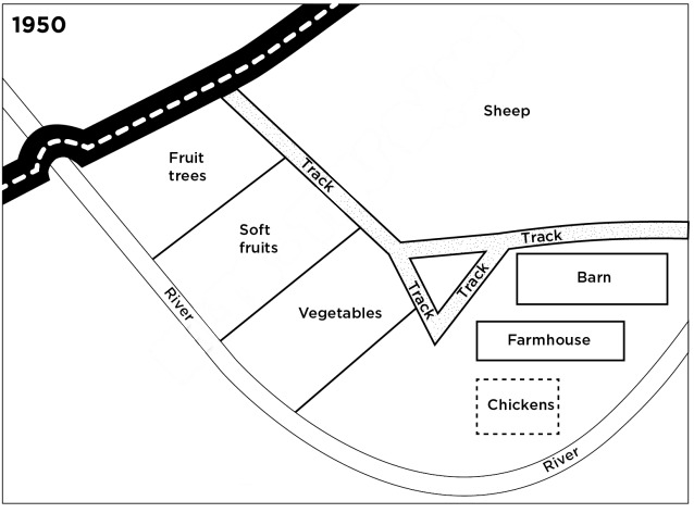
In 1950, the farm was primarily used for agriculture. Near the main road and the river, it had fruit trees, soft fruits, and vegetables. On the opposite side, a large section of land was used for sheep grazing. The farm also included a barn and a farmhouse, connected by a network of tracks, while a small area near the river was allocated for chickens.
Today, several major changes can be observed in this area. The sheep field has been completely removed and replaced with a camping site and a solar panel installation, indicating a shift towards tourism and renewable energy. A farm shop and parking area have been introduced near the entrance, enhancing the site’s commercial function. The internal transport routes have been upgraded from simple tracks to proper roads, improving accessibility. The barn has been relocated near the vegetable field, and a number of holiday cottages have been constructed in its previous location. Meanwhile, the farmhouse and chicken area remain, although their surroundings have been slightly reorganised. Despite these changes, the crop-growing areas for fruit trees, soft fruits, and vegetables have largely been preserved. It is obvious that the farm has evolved from a purely agricultural space into a multi-functional site combining farming, tourism, and energy production, with notable changes in land use, infrastructure, and purpose.
Sample Answer 2:
The two maps compare the layout of Beechwood Farm in 1950 with its current arrangement.
Overall, the farm has been extensively redeveloped, shifting from a purely agricultural site to a multi-purpose location that combines farming with tourism and energy production. While some traditional farming elements remain, large areas have been repurposed, and the internal infrastructure has been modernised.
In 1950, Beechwood Farm was dominated by agricultural use. The area near the main road was divided into fields for fruit trees, soft fruits, and vegetables, all situated near the river. To its opposite side, a substantial area was allocated to sheep grazing. A barn and farmhouse stood on the right side of the map, connected by simple tracks, and a small area close to the river was used for raising chickens.
These days, the layout has been significantly modified. The most striking change is the disappearance of the sheep pasture, which has been replaced by a camping field and a section of solar panels. A farm shop and parking area have also been added near the entrance, indicating increased commercial activity. The old tracks have been upgraded into roads, improving accessibility throughout the site. Additionally, the barn has been relocated, and several holiday cottages have been constructed nearby. Despite these developments, the crop-growing areas and the farmhouse have largely been retained.