IELTS Academic Writing Task 1/ Graph Writing – Maps:
You should spend about 20 minutes on this task.
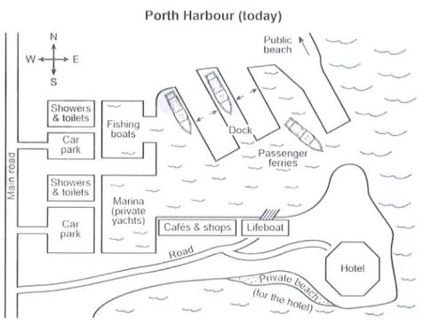
The plans below show a harbour in 2000 and how it looks today.
Summarise the information by selecting and reporting the main features, and make comparisons where relevant.
Write at least 150 words.

Model Answer:
The plans illustrate the maps of Porth Harbour in 2000, and compare the layout of 2000 with that of today.
Overall, the harbour has undergone significant commercialisation and redevelopment as more tourist-friendly infrastructure has replaced older features. As a result, the facilities have become more organised and accessible.
As the maps outline, in 2000, the southeast side of the harbour featured a derelict castle and a public beach, with no public recreational facilities. Today, the castle has been replaced by a sizeable hotel, and the adjacent beach has been privatised for hotel guests. A row of cafés and retail stores now lines the northwest shoreline, all connected to the main road via two new side roads. While the lifeboat station remains in its original position, its access has been improved.
On the western side, the original locations of the fishing boats and private-yacht marina have been swapped – the fishing boats now occupy the area once used by yachts, and vice versa. Although there were two car parks as well as public showers and toilets in 2000, by today, additional toilet and shower facilities have been installed beside the marina in its new location, and each car park is now linked to the main road by its own feeder road. In the northeast portion of the harbour, the public beach remains unchanged, but a new dock has been added to accommodate passenger ferries, greatly expanding the harbour’s capacity and commercial appeal.