Graph Writing # 87 - Chorleywood is a village near London whose population has increased steadily
- Details
- Last Updated: Saturday, 07 May 2022 12:20
- Written by IELTS Mentor
- Hits: 204229
IELTS Academic Writing Task 1/ Graph Writing - Map:
» You should write at least 150 words.
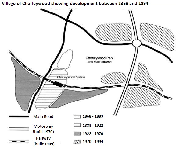
Chorleywood is a village near London whose population has increased steadily since the middle of the nineteenth century. The map below shows the development of the village.
Write a report for a university lecturer describing the development of the village.
» You should spend about 20 minutes on this task.
Model Answer 1:
The illustration delineates how the development of Chorleywood village in London took place from 1868 to 1994, over a period of 125 years. Generally speaking, development works in this rural area proceeded much rapidly during 1970 to 1994 than that or previous decades.
As the graph suggests, improvement in Chorleywood village was limited during the 19th century when area surrounded the Chorleywood station witnessed some development works. The railways were introduced in 1909 and it went across the station area and formed the ground for a wider development and constructions between 1922 and 1970, end of which the motorway was established in this village. The village went through rapid developments between 1970 and 1994 and had a wider roadway at this time. It is worth noticing that development and constructions in Chorleywood were guided by the transportation facilities as the junction areas witnessed a faster and large-scale progress than other areas. The park and the Golf course are in the middle of the village and train, road and motorways formed a hash (#) like road system in Chorleywood.
Sample Answer 2:
The diagram outlines the development that the Chorleywood village of London witnessed between 1868 and 1994. Overall, development works in this village were done in different periods and much of these constructions were done between 1970 and 1994. Interestingly, transportation facility defined the are of development in this village.
According to the diagram, the motor road was established in 1970 while the railway was built in 1909 in Chorleywood. Before 1900, only a portion of the village was developed and later (between 1883 and 1922) the station was built and some development works were finished. The area near the station was then improved and during the end of this construction, in 1970 to be precise, the motorway was completed. After 1970, the expansion process seemed accelerated and many areas of the village came under the renovation process. At the beginning of 20th century, the railway was built.
The land roads including the motorway, roads and railroads of this village connect almost all of the parts of the city and forms and hash like shape. The progress in this area had been done mostly based on the establishment of the transportation systems but the park and the golf course were placed in the middle of the village.

In detail, the main roads existed before the timeline provided. The railway was built in 1909 and the motorway was built much later - in 1970. The Chorleywood park and Golf course is enclosed by main roads at its North and West while the Eastern and Southern boundaries of the Park and Golf course is surrounded by motorway and railway respectively. A small patch of land near the Park and Golf course started developing from the year 1868 and the development continued till 1883.
Moreover, the Chorleywood station and its surrounding area underwent development between 1883 and 1922. Main roads are to the left of the Chorleywood Station area. A conspicuous relation can be drawn between the development of motorway and the development of areas nearby the motorway occurring between 1970 to 1994 as the development of areas near motorway eventuated after the construction of a motorway in 1970.
In general, what stands out is that the village had gone through a lot of developments in terms of expansion and transportation routes. It is noteworthy that the majority of the expansion occurred between 1970 and 1994.
Looking at the village on the 18th century, there were only two main roads, one running from northern-west to east side and another from north to southern-west, with only a small village along the mid-east side of the latter main road. However, this village expanded along the same main road from 1883 to 1922. Moreover, in 1909, the expanded portion of the village got a new railway station, which had a railway route from the east to the west side of the map.
From 1922 to 1970, the village grew bigger along the southern side of the railway. In 1970, a motorway was added to the village, which created two intersections on its way, one with the main road and another with the railway. Over 24 years from 1970 to 1994, Chorleywood village expanded along those two intersections.
In details, road communication was first developed in Chorleywood village in the nineteenth century and then the development of motorways took place in conjunction with the increase in population in the middle of the nineteenth century. Finally, the railroad was introduced in 1909 in this village and that was expanded till 1994.
Chorleywood Park and Golf course were located in the centre of the village. Main roads were at their left-hand side and top of the map. The other feature worth mentioning is that there was a development in between 1868 and 1883 at the left-sie of the Chorleywood Park and Golf course. The other significant development in this village was the construction of Chorleywood Station from 1883 to 1922. This construction was in progress with the building of the railway which was built in 1909. Subsequently, the other construction works were done surrounding the Chorleywood Station and were completed in around 1970. The remaining construction of this village began in 1970 and all of the developments were at the right hand of the Chorleywood Park and Golf course. In the meantime, in 1970, a motorway was built with a roundabout at the top right-hand corner of the park and golf course.
Report