Graph Writing # 141 - Changes that have taken place at West Park Secondary School
- Details
- Last Updated: Tuesday, 25 August 2020 23:44
- Written by IELTS Mentor
- Hits: 248888
IELTS Academic Writing Task 1/ Graph Writing - Map:
» You should spend about 20 minutes on this task.
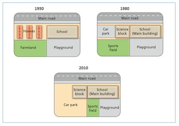
The diagram shows the changes that have taken place at West Park Secondary School since its construction in 1950.
Summarise the information by selecting and reporting the main features and make comparisons where relevant.
» Write at least 150 words.
Model Answer 1:
The diagram illustrates how West Park Secondary School has transformed over a period of 60 years since its establishment in 1950.
Overall, it can be seen that the school had undergone some significant changes throughout the period with the expansion of the school building, as well as the addition of a sports field and car park.
As the diagram shows, in 1950, the school had one building just right next to some houses. There was also a playground immediately behind the school and farmland located south-west to it. After 30 years, the houses were demolished to build a car park. Moreover, the building was expanded into two parts, one called science block and the other was used as the main building. Another noteworthy change that happened was the conversion of farmland to the sports field.
Looking at the school in 2010, the only marked change that occurred was the extension of the car park that occupied almost half of the total area of the school. As a result, the size of the sports field and the playground had to be shrunken to make way for the enlargement of the car park.
[Written by - Oyon]
Sample Answer 2:
The presented diagrams illustrate the changes the West Park Secondary School has undergone since its establishment in 1950. Overall, it is evident that the school area was expanded and the areas for the playground and sports field contracted.
As can be seen from the diagrams, the first time different modifications were made to the school ground was in 1980, when a new car park and science block were constructed where a group of residential houses used to be. The nearby farmland was also converted into a sports field.
In 2010, the most significant alteration to the school territory was the enlargement of the parking spot, which then covered the entire old sports field. In addition, the size of the playground had been reduced to make room for a new sports field.
To summarise, over the years West Park Secondary School has built and expanded some new facilities, such as the car park and science block, but at the same time, its playground and sports field have been reduced in size.
[ Written by - Thu Trinh ]
Sample Answer 3:
The given pictures illustrate the various developments of West Park Secondary School from 1950 to 2010. Overall, it is clear that the main road remained in place over the given period of time and It is also apparent that the school was developed and increased in size while areas of the sports field and playground decreased.
To begin, there were three rows of houses in 1950 which were converted into car parking lot and science block in 1980. There was farmland near the houses in 1950 but it was altered into a sports field in 1980. The sports field was then being replaced by a bigger area for car parking in 2010.
Furthermore, the school in 1950 had one large block which later on took an additional block called science block. After the emergence of the science block, there was no place for housing. The playground area remained unchanged from 1950 to 1980 but was reduced in size as the remaining area was used as a sports field in 2010.
[ Written by - Lee Wing Qeen ]
Sample Answer 4:
The provided diagram shows the changes West Park Secondary School has undergone since it was first established in 1950.
As is presented, the school has gone through some major changes and has also remained the same since 1950. When looking at the diagrams, you can see that the main school building has not changed at all. There was an additional building added on in 1980 called the Science block which was added to accommodate the increase in student enrolments, which it was not anticipating. The only other major changes have been to its surroundings. According to the school’s layout diagram of the year 2010, there has been an increase in the size of the car park compared to the 1980’s school layout diagram. When deciding to increase the school car park area, certain school facilities had to be sacrificed, for instance, the sports field is a third of its size compared to the 1980’s school layout diagram. The playground was also downsized by a quarter of its original size in 1950 and 1980.
My conclusion is that these changes had to be done in order to accommodate a major increase in enrolments of students since its establishment in 1950 and maybe also due to the growth in population and developments in their area.
[ Written by - Shirley Gee ]
Sample Answer 5:
The maps illustrate the development and alteration that have happened at West Park Secondary School since it was first built in 1950.
The school building and the main road have not changed throughout the years. Houses to the left of the school were removed in 1980 and the car park with the science blocks was constructed next to the school instead. Farmland at the left bottom of the map was taken up by school and developed into a sports field for children in 1980. However, in 2010 the car park was increased in size and took the whole area of the field. Subsequently, as there was a need for sports, the huge area of playground situated at the right bottom corner have been cut by one-third and replaced by a sports field.
In brief, the area for the past 60 years has been profoundly changed and optimised for the schools’ various needs.
[ Written by - Isaeva Alena ]
Sample Answer 6:
The diagrams illustrate how West Park Secondary School has developed during the period of 60 years since it was first built in 1950. Overall, the school area has been expanded and a car parking area consumed a great deal of space over time while the farmland was converted into a small sports field.
Initially, in 1950, West Park Secondary School's ground area consisted of a school building and a playground behind it. 3 blocks of houses and farmland occupied the rest of the area. 30 years later, the residential place was replaced by a car park and science block which was located next to the main building of the school. Meanwhile, the farmland was converted to a sports field. In the year 2010, the car park increased in size which now occupied the area where the sports field used to be in 1980. As a result, the playground area was reduced by a third to make room for the sports field.
[ Written by - Thu Phuong Luong ]
Sample Answer 7:
The diagram presents West Park Secondary School at three different stages in its development: 1950, 1980 and 2010. As can be seen from the given illustration, the school went through different changes.
In 1950, the school was built near the main road and near the school, there was a place for housing. An extensive spot behind the school was fixed for a playground, while the field behind the housing was farmland. By 1980, the housing area had been knocked down in order to build a science block and a space for car parking. Moreover, a new sports field was established in the exact area where the farmland was and it is right next to the playground. In 2010, the school's main building and the science block were still intact but the car parking area had been extended and it consumed a great portion of the sports field and playground. During the given time, the area around West Park Secondary School has changed. In addition to a new science block, a larger car park has been constructed and extended. Hence, the spot for the sports field and playground reduced.
[ Written by - Ganis ]

Overall, it can be seen that the school had undergone some significant changes throughout the period with the expansion of the school building, as well as the addition of a sports field and car park.
The rows of houses relocated to the left of the school in 1950, were demolished and replaced by a parking lot. Besides, an office block was added to the site after the residential area was pulled down. As for agriculture, the area was made into a sports-playing area after 30 years.
From 1950 to 1980, the school playground occupied a massive area in front of the teaching area; however, by 2023, this recreational space has been reduced by about a third to accommodate the sports playing area. As a result, the sports field was dug up and paved over to allow for the car park to be extended.
Overall, in over 60 years, the particular land went through different changes. Only the school area remained the same and most of the area was dedicated to the car parks.
In 1950, the land was separated equally into four sections for residential houses, the school, farmland, and playground. After 30 years, in 1980, some changes were made in that particular land. Many housing areas were demolished and that space was used for car parks and science blocks. The School section remained the same but that was used for the school's main building. Likewise, farmland turned into the sports field but the playground remained the same.
In 2010, several changes were also made in that land. Even bigger space was provided for the car parks. And the playground section was divided into the sports field and playground. But a very small area was separated for building the sports field. The science block and school (main building) area remained the same.
Overall, houses near the school were demolished for the development of car parking spot and sports field, and the Science block was annexed to the main school building over time.
It can be clearly seen from the diagram that in 1950, the school was located beside the main road and this location remained unchanged over the decades. The initial structure of the school, established in 1950, included a block of dwellings and farmland. The farmland was behind the houses and adjacent to the playground. The playground was remarkably large, even larger than the school building.
After three decades, the school authority introduced a car parking area and the 'Science block' and demolished the houses to make space for the parking area and science block. The playground was untouched and the farmland was converted to a sports field.
Finally, in 2010, car parking got even bigger and consumed a larger portion of the map. The expansion of the parking area shrank the sports field and the playground. All other structures remained almost the same as it was in 1980.
Report